DISCOVER BLUEGIS
Drone - Cartography - GIS
 |  |  |  |
|---|---|---|---|
 |  |  |  |
 |  |  |  |
 |  |  |  |
 |  |  |  |
 |  |  |  |
 |
ABOUT US
BlueGIS offers GIS project monitoring, webmapping, UAV aerial imaging and drone mapping services.
We work with public organizations, companies, local authorities, associations and individuals.
Our experience in terms of Geographic Information System (GIS) and spatial analysis in a wide variety of applications allows us to support the different actors of the territory in a better understanding and representation of their projects.
Contact: bluegis@outlook.fr


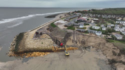
Floods - Submersion
Forest fire - Landslide
Agricultural and viticultural monitoring
Mapping of natural areas
GIS software - Database
Drone mapping - Photogrammetry
NOS CLIENTS


Antoine Pouget
Cartographer, geomatician, passionate about the coast and the environment.
About us
After more than 5 years of varied experiences in the field of Geographic Information Systems, I launched my service activity in cartography.
Geomatician and UAV pilot approved by the French civil aviation since 2015, I have skills ranging from cartography and GIS in general, to mapping by drone.